Summary
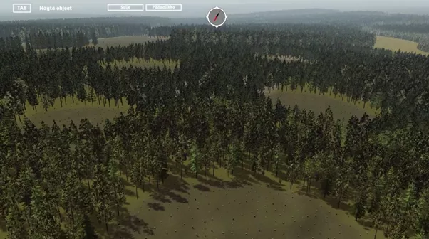
The Virtual Forest 2.0 initiative in Finland improves forestry practices and resource management through a digital tool that uses geographical and forest data to create a virtual forest. The project developed the Virtual Forest application to simplify the process of transferring data from forest resource databases to visualisation platforms and enable visualisations of various growth sites and forested areas.
Expanding its reach beyond Lapland, the initiative introduced growth site modelling to enhance the precision of tree placement within the virtual forest environment. It also advocated for the integration of remote sensing and other openly available resources for visualising forest resource data, investigating their broad application in decision-making within the forest industry.
The project tested the application, incorporating state forests, participatory planning and the coordination of livelihoods in practical scenarios. This entailed the active involvement of forest service companies and public sector stakeholders in participatory land use planning.
Results
Virtual Forest 2.0 is a new technological tool aimed at facilitating inclusive planning of natural resources. It underwent testing during the project’s demonstrations with forestry experts and events, incorporating the following features:
- Enhanced automated generation of real-time, 3D virtual forests from forest data for visualisation purposes;
- Exploration of techniques for generating expansive 3D forest environments within a game engine, based on data sourced from GIS software designed to capture, store, manipulate, analyse, manage and present spatial or geographic data;
- Evaluation and refinement of remote sensing data use, such as light detection and ranging (LIDAR), in the creation of forest visualisations;
- Development of accurate and high-quality visual representations for each vegetation zone to ensure a realistic depiction of planned actions;
- Integration of a SIMO (single input multiple output) calculation model for simulating forest growth, which considers various planning parameters, facilitating coordination among different stakeholders operating within the same forest areas.
Virtual Forest 2.0 has garnered interest both in Finland and internationally – the application has been adopted by subsequent initiatives, expanding the scope of visualisation to incorporate other areas such as berry growth and simulations of heavy forest machinery. Continuation projects include:
- MESI project (development of Metsäkone simulation training), funded by the European Social Fund during the 2020-2022 period;
- AGRARSENSE project (smart, digitalised components and system for data-based agriculture and forestry), funded by the Chips Joint Undertaking and the Swiss Confederation during the 2024-2025 period.
Resources
Documents
Context
Forests play a significant role in the local economy and ecosystem of Lapland. However, foresters in the region face several challenges in managing land and forest resources. Balancing competing land uses, like forestry and tourism, against conservation imperatives presents complex land use conflicts. Access to raw material, multi-objective planning and different interests of multiple stakeholders meant a new digital tool for planning the use of natural resources and land was required. Additionally, there was also a need for a new tool for social licensing and participatory planning in the forest industry.
Initially, Virtual Forest was developed as a learning environment for forestry students at the Lapland University of Applied Sciences (Lapland UAS). Following its initial success, an improved Virtual Forest 2.0 was developed to serve the larger forest industry.
Objectives
-
Develop methods of visualisation of forest information in different vegetation zones;
-
Improve the sector’s use of forest information visualisation by increasing the quality and depth of visualisation.
Activities, key actors, and timeline
-
Development of a Virtual Forest prototype on the basis of forest and natural resource data gathered by the project in the visualisation;
-
Testing of new ways to use forest data through the new prototype;
-
Development of the Virtual Forest application for visualising forest information by the FrostBit software lab at Lapland UAS, including:• 3D modelling• Initial environment generation system• Integration of the geographic information system (GIS) and a visualisation tool• Expanded visualisation of forest data• Enhanced models and generation system to encompass additional vegetation zones• Visualisation of forestry operations, such as tree felling or forest soil preparation;
-
Updating the application involves broadening the use of natural resource data in visualisation, incorporating both existing open data, such as forest stand data, and gathering and integrating new remote sensing data, such as laser scanning;
-
Organisation of events with forestry engineering students, forestry professionals and other stakeholders to test the application and ensure the project outcomes are effectively used by students and private sector professionals;
-
Publishing updated versions tailored to various uses.
Success factors/lessons learnt
The project collected feedback from forest owners, entrepreneurs and enterprises engaged in the events. The application was deemed beneficial for both remote and face-to-face forest counselling sessions.
The incorporation of new technology into traditional industries like forestry facilitates the co-existence of various industries with distinct goals and business models within the same forest areas.
The Virtual Forest 2.0 application simplifies the comprehension of landscape changes and their potential impact, such as on tourism in the same area, more effectively than raw planning data or static reference images. Moreover, in education, forestry students can grasp the significance of forest planning decisions from both an economic and landscape perspective.
Contacts
Lapland University of Applied Sciences
Anne Saloniemi: anne.saloniemi@lapinamk.fi
Pertti Rauhala: pertti.rauhala@lapinamk.fi

